| Contact us |
| Try wildfowling |
| Club merchandise |
| Wildfowl art |
| Wildfowling books |
| Join KWCA |
| Search |
Conservation ESA
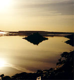
The North Kent Marshes Environmentally Sensitive Area
The KWCA has two areas entered into the ESA scheme: the marsh at Cooling
and Harty Fields.
The ESA forms an almost continuous coastal marshland
fringe extending from Whitstable in the east to Gravesend on the Thames
estuary in the west, including the Medway estuary and the Isle of Sheppey.
The marshes are typically two to five kilometers wide but they broaden
on the Hoo peninsular and on the southern side of the Isle of Sheppey.
The ESA extends, in total, to 13,715 hectares and is bounded by a belt
of higher ‘upland’ which forms a pronounced landscape feature
defining the southern boundary. Most of the marshes have been enclosed
by sea walls (‘inned’) since medieval times to prevent flooding.
The marshes are a distinctive, exposed, flat landscape of pasture land,
with mudflats and saltings beyond the sea wall. In combination, they provide
a habitat of international significance for over-wintering and breeding
birds. Part of the ESA has been designated as a Special Protection Area
under the EC Directive on Conservation of Wild Birds (79/409) and as a
Wetland of International Importance under the 1971 Ramsar Convention.
The marshes, ditches and dikes contain important aquatic flora and invertebrates,
and most of the area has been designated as a National Nature Reserve
or Sites of Special Scientific Interest.
Download the full PDF (300k) report ENVIRONMENTALLY
SENSITIVE AREAS SCHEME which details environmental monitoring in the North
Kent Marshes ESA, as reported to Ministry of Agriculture, Fisheries and Food (MAFF),
now DEFRA, covering the landscape, wildlife and areas of historical interest.
To view the PDF files you need
Adobe Acrobat. Click on the icon below to access the Adobe web site and download
the free software needed.
![]()